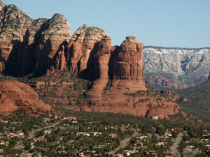
West Sedona is home to most of Sedona’s grocery stores, banks, and residential areas but it also the place to find some of Sedona’s best shops, restaurants, tour companies, book stores, state parks, scenic drives, hikes and sightseeing spots. Heading up the hill from the “Y,” you’ll discover dramatic views to your right where two of Sedona’s most well-known rock formations merge into one - Thunder Mountain and Coffee Pot Rock.
Definition: The “Y”. What was once a Y-shaped traffic light intersection is now two back-to-back roundabouts we're still picking names for - so call it the Figure 8, the Vortex, an intersection or what have you, we’ll refer to it as the Y because we’ve known it that way for so long!
*Did you know? Thunder Mountain was actually the inspiration for Walt Disney’s Thunder Mountain ride at Disneyland! Mr. Disney himself came to visit Sedona and was so awestruck by this godly creation, he decided to craft one of the park’s most infamous rides after it.
There are several scenic drives you can take throughout West Sedona up Airport Road to Airport Mesa, down Dry Creek Road to Boynton Canyon, and down Upper and Lower Red Rock Loop Road to two picturesque State Parks, Crescent Moon Ranch and Red Rock State Park. We’ll break these down by road so you can decide which drives you’d like to take or plan to take them all!
Airport Road
Airport Road leads to the top of Airport Mesa where a scenic lookout offers an incredible bird’s eye view of our sprawling community. You’ll see Mingus Mountain and Jerome in the distance, spot rock formations like Chimney Rock, Cockscomb and get eye to eye with Thunder Mountain and Coffee Pot Rock. This spot is no secret so many gather here at sunset each evening to experience the magic of red rocks lit on fire - their crimson hues matching the colors of the sky. You’ve never seen anything like it. Sunrise is equally as spectacular (and might allow for a little more privacy since most folks sleep in when they’re vacationing) so if you’re an early riser, try starting your day at the top.
On the way up Airport Road, you’ll see a pullout to your left. Here you can take a short hike up a knoll and get full 360 degree views. This area is considered a vortex so you might have a unique experience here. If nothing else, you can tell the folks back home you sat on a vortex!
Want to know more about vortexes? This article at About.com explains all about Sedona vortexes.
At the top of Airport Mesa, beyond the scenic lookout, the road quickly dead ends into a dirt parking lot where you’ll find Red Rock Biplane and Sky Safari helicopter and biplane tours through the air. We highly recommend these tours. You haven’t seen Sedona until you’ve seen it from above!
Dry Creek Road
On the far west end of town (which is only about three miles from The “Y”), you’ll see Dry Creek Road heading north into the distance. Rock formations like The Cockscomb, Devil’s Bridge, Chimney Rock. Boynton Canyon, Fay Canyon, Vultee Arch and many more offer eye candy for a nice drive as well as dozens and dozens of moderate to adventurous hiking trails in every direction.
Dry Creek Road is a little over a mile long in total. When you reach the first stop sign, turn left onto Boynton Canyon Road and you’ll continue towards Boynton Canyon and Fay Canyon. Along the way, you’ll spot trailheads on the right and the left.
Boynton Canyon Road turns into Boynton Pass Road which after about 2.5 miles (just follow the signs) leads to the Honanki and Palatki Heritage Sites. Discover well-preserved ancient ruins where the original settlers of this area, the Sinagua, lived from about 1100 A.D. to 1300 A.D. A 1/4 mile trail leads first to the Rock Art site where you’ll see over 1,000 ancient pictographs carved and painted into the red rocks by generations of Verde Valley inhabitants. A little further up about 50 steep steps, you’ll find the cliff dwellings. Around these 2-story dwellings, you’ll find traces of these ancient ancestors of the Hopi in the form of petroglyphs, rock art, shards of broken clay pots, and the remains of their dwellings. These were the largest cliff-dwellings in Red Rock Country for this time period.
Strangely enough, these two sites are not related to each other despite their close proximity. The Rock Art site dates back over 6,000 years, thousands of years before the Sinagua came to call this land home. The Sinagua mysteriously disappeared around 1300 A.D. and to this day no one knows why but we are all fascinated by the remains of their ancient dwellings.
Currently managed by the U.S. Forest Service under the Red Rock Pass Program, the site is open to the general public for visits seven days a week (closed Thanksgiving and Christmas) from 10 a.m. to 6 p.m. Please call the Red Rock Ranger District at 928.282.4119 or Palatki at 928.282.3854 before you go.